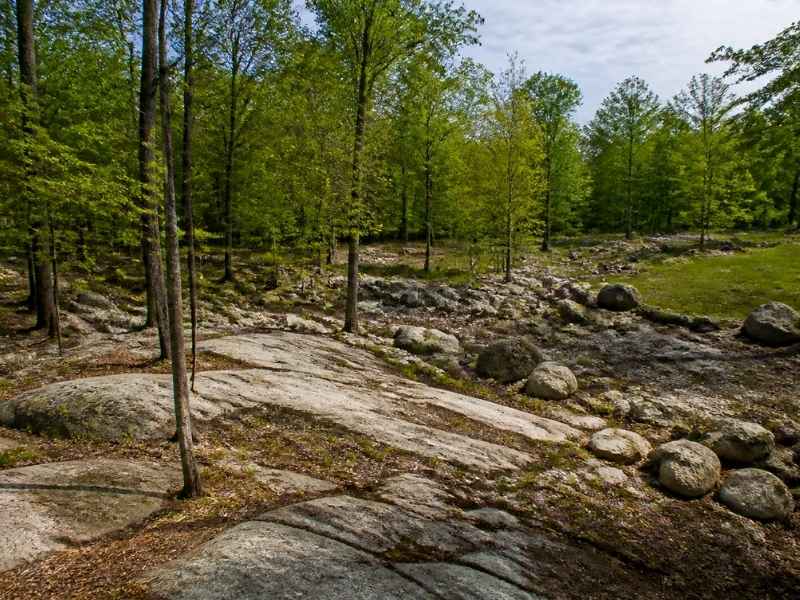
A boulder you can see is easy to plan around. The ledge hiding a foot under the grass is what wrecks a build budget. Rocky land can make a great home site, but only when you know what’s on it and what’s likely under it.
That’s why buyers, builders, and owners should start with a detailed survey before design begins. A land surveyor maps rock outcrops, slopes, elevation changes, and drainage so your design team works from real ground conditions. The map won’t tell you everything about the rock below, but it shows where to test and what to plan for before anyone digs.
Beyond Surface Boulders: Identifying Hidden Terrain Constraints Before Site Development
The biggest problems on rocky land are often the ones you can’t see from the driveway. Shallow bedrock, buried boulders, steep grades, and water with nowhere to soak in can all sit hidden under trees and topsoil. A quick site walk will miss most of them.
Glaciers shaped a lot of rocky ground. They left a mix of loose stone, packed soil, and ledge, which is the common term for solid bedrock near the surface. Soil depth can change fast, so one corner of a lot may have three feet of dirt while a spot twenty feet away has rock right at the top.
A land surveyor turns those surface clues into a scaled map. Exposed rock, boulder fields, stone walls, sudden drops, and wet spots all get located and drawn. Those features hint at what’s going on underground and help you choose where test pits or borings should go. Catching rock problems on paper costs far less than finding them with an excavator.
How Does a Land Surveyor Document Steep Slopes, Rock Outcrops, and Elevation Changes?
A land surveyor documents rough terrain with a topographic survey. Field crews collect elevation points across the site and use them to draw contour lines. Contours connect spots of equal height, so tight spacing means steep ground and wide spacing means flatter ground.
On rocky land, the number of points matters a lot. Widely spaced shots can smooth over a rock ridge or a sharp drop and make the site look easier than it is. Ask for denser coverage where you plan to build, and ask that rock edges be located and labeled on the map.
Crews may use a total station, GPS receivers, drones, or laser scanning, depending on tree cover and site size. Thick woods and broken rock can block some tools, so many crews mix methods. A good topo of rocky ground should include:
- Contours at an interval that fits the project
- Spot elevations at the top and bottom of steep slopes and rock faces
- Outlines of exposed ledge and large boulders
- Stone walls, trees, structures, and other site features
- Property lines, so the building area ties to the actual parcel
Mapping Natural Drainage Paths Where Bedrock Limits Water Infiltration
When bedrock sits close to the surface, rain can’t soak in very far. Water runs across the rock or along its top, then shows up downhill as runoff, wet spots, or seeps. Mapping those paths early keeps you from putting a house, driveway, or septic area right in the way.
A land surveyor locates the low points, swales, channels, and culverts that show where water already moves. Water flows at right angles to contour lines, so a good topo makes flow direction easy to read. Ponding areas and signs like washed-out soil or stained rock should be noted for the design team.
Some wet areas may be regulated as wetlands or watercourses. A soil scientist or other qualified professional usually marks those limits in the field, and the surveyor then maps their flags. Rules, setbacks, and permit steps can vary by town and project, so confirm what applies to your site early.
Shallow rock also affects septic planning. A system needs enough suitable soil above ledge and groundwater, and the required depth depends on local health codes. Your surveyor can locate each test pit so those results sit on the same map as the terrain.
The Role of Topographic Data in Planning Excavation, Access Roads, and Building Placement
Topographic data is the base map for every other design choice. Engineers and builders use it to place the house, lay out the driveway, and estimate how much soil and rock must move. Without accurate elevations, those numbers are guesses.
For excavation, designers compare existing grades with proposed grades. That comparison shows where you’ll cut into the hill and where you’ll need fill. On rocky land, deeper cuts may mean hammering or blasting, so sliding the house a few feet can save real money.
Access roads and driveways need grades that cars, delivery trucks, and emergency vehicles can handle. Towns often limit driveway slope, and those limits can vary. An accurate topo lets your designer test routes around ledge and steep pitches before the layout is locked in.
Building placement pulls it all together. The best spot balances views, sun, setbacks, rock depth, and drainage. When boundaries, outcrops, and grades appear on one sheet, those trade-offs are much easier to see.
What Should a Land Surveyor Flag Before Foundation Design Begins on Rocky Terrain?
Before foundation design starts, a land surveyor should flag anything that could change the footprint, depth, or type of foundation. Some of these items come straight from the field work. Others come from record documents like your deed and plat. Make sure the final map shows:
- Rock outcrops and large boulders in or near the planned footprint
- Steep slopes that may need retaining walls or stepped footings
- Low spots and flow paths that could send water toward the foundation
- Test pit and boring locations, with ground elevations at each one
- Property lines, recorded easements, and setback lines where they apply
- A benchmark, which is a fixed point used to check elevations during construction
A surveyor doesn’t decide how deep the rock is or which foundation to use. Those calls belong to a geotechnical or structural engineer, who checks conditions below grade with borings and test pits. The survey gives them an accurate base so their findings line up with the real site.
Ask for deliverables in both PDF and CAD formats so the engineer can work straight from the data. Confirm the coordinate system and elevation reference before design begins. A small mismatch there can throw off grades once stakes go in the ground.
Frequently Asked Questions
Can a land surveyor tell how deep the bedrock is?
A land surveyor can’t tell rock depth from the surface alone. They map what’s visible and measure surface elevations across the site. Rock depth usually comes from test pits, borings, or other subsurface testing done by an engineer or excavator. The surveyor can then locate those test spots so the results line up with the topo map.
Do I need a topographic survey for a rocky lot if I already have a boundary survey?
In most cases, yes. A boundary survey shows where your property lines are, but it usually doesn’t show detailed elevations or rock features. A topo survey adds contours, spot grades, and site features that designers need for grading and foundations. Many surveyors can combine both on one map if you ask when you request a quote.
How early should I order a survey before building on rocky ground?
Order it before your architect or engineer starts design. The survey shapes where the house can go, how the driveway runs, and how much rock may need to come out. Permit timelines and lender needs can also depend on having survey data ready. Busy seasons can push field schedules back, so it’s smart to book early.